Karstification
Kefalonia is the largest island in the Ionian Sea and presents a variety of geoforms which are directly related to its lithological and tectonic features. The main part of the island consists of rock formations of the Pre Apoulia zone, and part of it is covered by rocks of the external Ionian zone. Limestones dominate the island, especially at the area of Sami which is characterized mainly by limestones deposited during the Mesozoic Era(252-66 My).
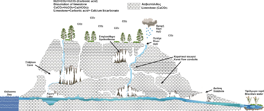
Limestones are sedimentary rocks that cover more than 1/4 of the earth's surface; their main component is calcium carbonate (CaCO3), which reacts slightly with water. It is mainly marine sediment formed in earlier geological times by continuous slow and steady precipitation of shells of various organisms that lived in the earth's seas made of calcium carbonate. These sediments were more enriched in calcium carbonate (CaCO3) contained in seawater and by their continuous deposition, they create layers of different thickness depending on the conditions prevailing in each area. Due to a series of physicochemical phenomena known as diagenesis, this marine sediment slowly solidifies and eventually turns into solid limestone.
Because of the movements of the plates that the earth’s crust consists of, orogeny was initiated and as a result limestones that were formed at the bottom of the seas, form entire mountains and constitute a large percentage of the land. The initial sediment, which had been compacted, breaks and cracks under the impact of great tectonic forces. Water flows through these cracks (these cracks can be fractures and faults that are created, depending on the impact of the force), and creates karst phenomena and forms (the name karst comes from the Carso area Slovenia east of Trieste where the phenomenon was first observed and studied) which are ultimately responsible for the formation of most caves. The term karst originally meant a field of stones, but today it has been conceptually extended to every geomorphological feature, either superficial or underground, due to the water dissolving power of freely soluble rocks.The underground drainage is the main characteristic of these areas. Even areas that receive heavy rainfall are stripped of vegetation due to the dranaige of water inside the rocks (infiltration).
The ratio of pure water to calcium carbonate must be 75,000: 1 in order to dissolve. However, when rainwater falls to the ground, it is enriched with carbon dioxide (CO2), which comes either from the atmosphere or from the decomposition and respiration of plants. Carbonic acid is a weak acid that is formed from the reaction of carbon dioxide dissolved in water(H2CO3) CO2 + H2O ↔ H2CO3, and which is acting as a weak acid dissolving the carbonate rocks(karstic corrosion). Thus as the water is enriched in carbonic acid, during the reaction H2CO3 + CaCO3↔Ca (HCO3)2, the limestone (calcium carbonate) is converted to acidic calcium bicarbonate. The reaction shifts, either in case of excess CO² to the products or when there is a shortage, to the reactants, in which case we have dissolution or precipitation of CaCO3 depending on the case.
Over time, water flows into the cracks (fractures and faults) of the rock, widens them and thus forms a peculiar landscape on the surface with geomorms such as karrens, karstic lakes, springs, sinkholes, poljes and a complex system of underground cavities and conduits, within the mass of limestone, characterized by the term karst. The continuous flow of water is necessary to continue the dissolution. The speed of these reactions depends on the quantity and quality of water (salt concentration, total dissolved carbon dioxide and pH), temperature, pressure, and finally the purity of the limestone. The most well-known underground karst forms are cavities with an irregular arrangement such as caves, precipices and the phenomenon is called karstification. A cave is defined as any underground cavity in which a human can fit.
Karstification process in Kefalonia Island
In particular, in the area of Sami, numerous karstic phenomena occur as a result of the combined effect of lithology (limestones), tectonic activity (fractures and faults), climatic conditions as well as erosion and depositional processes. Approximately 17 sites of caves and karstic lakes have been recorded, which were formed in the limestones of the Pre Apoulia zone, deposited during the Mesozoic Century (251-65 My) and mainly during the Cretaceous and Paleocene.
The geological conditions prevailing on the island favored the formation of a wide variety of underground and terrestrial karstic formations, especially in the area of Sami as it is located on the eastern coastal zone of the island. It is located near the Ionian thrust along which during the Lower Pliocene (5.3-3.6My) its propagation on the autochthonous Pre Apoulia zone took place. This event is the most important tectonic event on Kefalonia island.
Therefore, the high degree of karstification observed in this area depends on the limestones that appear strongly tectonised due to their location, where in combination with rainwater that flows through the cracks (fractures and faults)and the dissolved CO2, facilitates the dissolution of calcium carbonate resulting in the formation of karstic formations such as caves (Drogarati), dolines(AgioiTheodoroi, Chiridoni, Sotira, Zervati), pothole caves (AgiosEleousa, Agalaki), cenotes (Melissani,Fytidi, Agioi Pantes, Vrouspa, Agalaki, Xerovrouspa, Liarou Hole, Angelatou Hole, Papa's Hole, Lakuditsa) underground rivers and karstic lakes (Karavomylos, Abythos). Most of them are geosites of the Geopark.
The phenomenon that has engagedseveralresearchers is the fact that the karstic formations that develop in the area of Sami just above or below sea level, communicate with each other through a karstic system of conduits of flowing water, (karstic hydrological network) where brackish waters from the interior flow to the coastal zone of Karavomylos. The most impressive event, however, is the connection of the Argostoli-Sami karstic hydrological axis (Argostoli Sinkholes - Karavomylos area). More specifically, in the Sinkholes of Argostolithe sea water inflows, comes in conduct with karstic conduits of flowing water and mixes with fresh water, which comes from higher layers and specifically from limestones of the mountain Aenos. As a result, fresh water mixes with seawater, and springs as brackish water at higher altitudes above sea level, 15 Km east, in the wider area of the coastal zone of Karavomilos.
There are three possible factors that simultaneously act and explain the phenomenon. The first factor is the energy of the Aegean-Adriatic Sea current which has as a consequence the formation of a higher sea level in the Sinkholes of Argostoli, by 2-30cm, in relation to the area of Karavomylos. The second and more important factor is the difference in density between seawater flowing into the sinkhole (1,258 kg / dm3 at 25οC) and brackish water flowing from the springs (1,0002 kg / dm3 at 15οC). The third factor is the existence of deep karstic conduits, such as siphons, which operate underwater, contributing to the creation of the phenomenon in addition to the action of the Aegean-Adriatic Sea current.
Similar karstic phenomena have been also observed in other places around the world, nevertheless the hydrogeological mechanism that controls the karstic system of Kephalonia sinkholes cannot be found anywhere else, thus, this phenomenon can definitely be considered as one of the most spectacular and interesting hydrogeological phenomena in the world and which preoccupied geoscientists for about 150 years. These data are 1) the steady inflow of seawater in the sinkholes, which crosses the entire island, and outflows as brackish water in the opposite side of the island at the springs of Karavomilos, 2) the significant flow rate of seawater in the sinkholes which has been measured up to 3m / sec, and 3) the fluctuation of the suction speed, depending on the amount of atmospheric precipitation.
The first conclusions about the karstic complex of Argostoli - Sami region sinkholes came in 1963 from, after the Austrians Zötl and Maurin introduced pigment (160 Kgr of uranine, chemical detector) in the sinkholes of the Argostoli area and they observed their communication with the springs of Sami area after fifteen days. The distance between the Sinkholes and the springs in a straight line is 15km.
Many hypotheses have been made to explain this phenomenon through various mechanisms. The most common of which is the theory of ocean tides and strong winds that have been used to explain similar phenomena but cannot be applied to the island, due to the uninterrupted inflow of water. It is therefore not possible to interpret the cause of the phenomenon in periodic floods or winds, as they do not provide a constant force and direction.
According to studies that have been carried out on the phenomenon, the following factors seem to contribute:
- The sea level on the side of the sinkholes is higher than the discharge springs in the area of Sami. This fact is due to the energy of the Aegean-Adriatic current and is the initial cause of the phenomenon. It should be noted that the phenomenon of altitude difference in sea level does not always apply, but is interrupted for a few hours of the day. Thus, while the hydraulic slope described is a cause of the flow effect, it is nevertheless not the only reason, since the flow continues even when the altitude difference is zero. It has been also observed that the water table level in Sinkholes of Argostoli is at -1.70m in relation to the sea level, while in the opposite side near the springs of Karavomilos, the water table level was recorded at -0.73m. This means that it is located one meter higher (existence of a piezometric slope opposite to the flow of groundwater).
- Consequently the movement of the water from Sinkholes of Argostoli to the springs of Karavomilos would be completely extraordinary if there wasn’t difference in the density of groundwater. Therefore, seawater (higher density) enters through the Sinkholes, comes in contact and mixes with the fresh water which originates from the penetration of rainwater in the carbonate rocks of Mount Aenos. Then this water which is filtered through the karstic network of the limestone rocks of Aenos, gashes as brackish water in the other side of the island, in the coastal zone of Karavomilos. Groundwater flow can be schematically simulated with communicating vessels which contain water of two different densities, as the hydrostatic equilibrium forces water to move to the side with the lowest density.
- Also in the existence of a karstic underground conduit network. The underground flow is realized through a permeable, karstic conduit and mainly through a large conduit (A-A1) that connects the West side of the island (Argostoli area), with the East (Sami area).The hydrographs that have been carried out in all the caves of Sami gave main axes with direction N-S, which is very close to the direction of the sinkholes which are NE-SW. From this conduit network however, only parts of it are maintained. The cause of the destruction of this karstic conduit happened due to the numerous faults that exist on the island with mainly N-S orientation. This fact explains the fortnightly delay of the pigment from Argostoli to Sami as well as the small negative altitude difference of the sinkholes compared to the springs. The creation of this karst conduit originally came from the lowering of the sea level during the Messinian (7 million years ago), which allowed the development of the coastal karstic conduit network in the area of Argostoli. Then, when a rise in sea level happened, this network became submarine, and subsequently a new withdrawal during the last ice age, which started 18,000 years ago.
- Finally, because of this conduit, the rain water from the area of Argostoli was transported to the east. "Now that the entire conduit, or parts of it, is below sea level, the hydrostatic pressure has been equalized, so the flow should have stopped."Nevertheless, the eastern side of the island continues to be supplied through the eastern karstic network and through an additional conduit network which was created due to the penetration of rainwater in the area of Aenos. Consequently, as these two conduit networks meet, the flow velocity increases during the periods of heavy rainfall resulting in the phenomenon of suction, which activates the aspiration of seawater in Argostoli with high velocities (Bernoulli Theory).