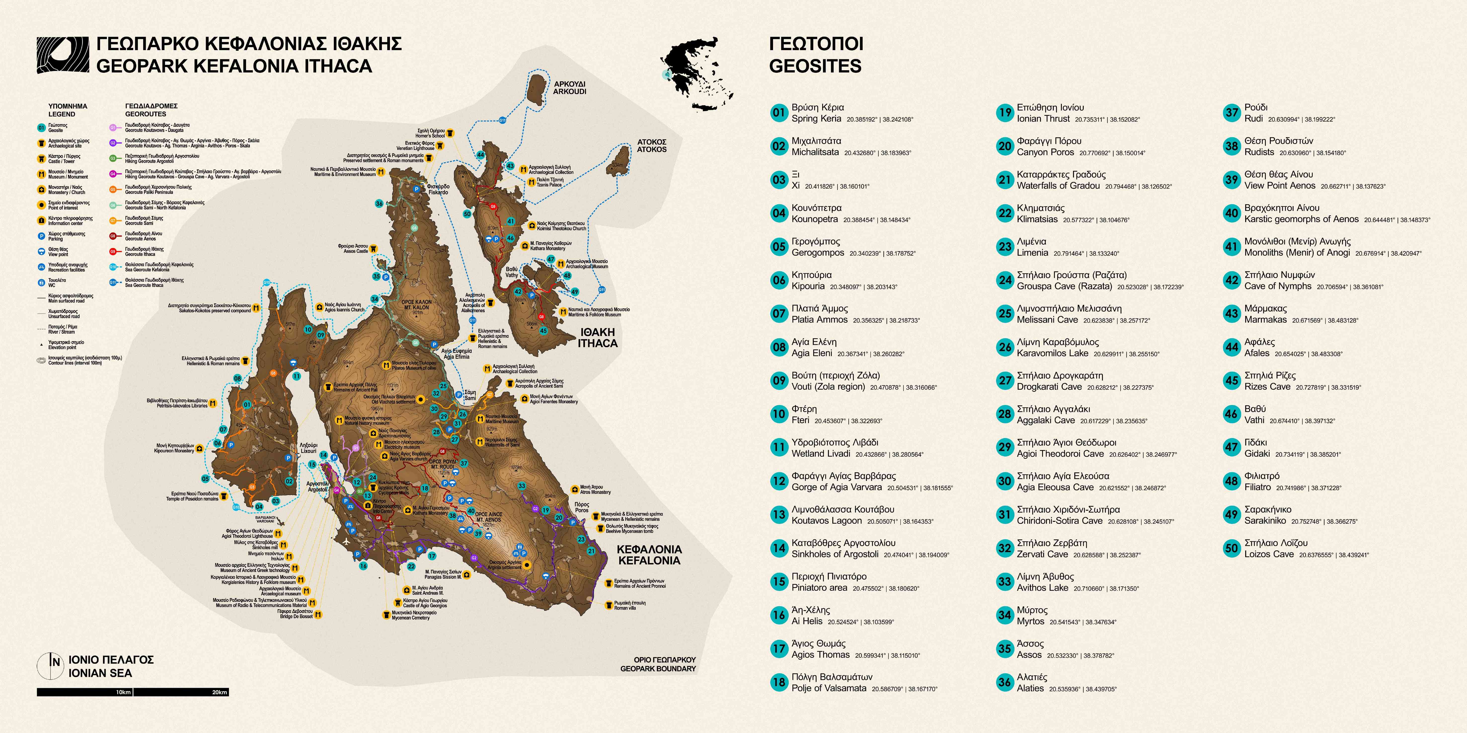
Georoute No 1: Koutavos Lagoon - Gorge of Agia Varvara - Grouspa Cave - Davgata - Argostoli
The georoute starts from Geosite Koutavos Lagoon, an important wetland of the island, where it is located the Information and Training Center of the Geopark at the headquarters of N.E.C.C.A.. We head towards Geosite Gorge of Agia Varvara, a relatively small gorge at the foot of which it was built the homonymous church inside a cave. We continue towards the village of Faraklata, where we can visit the Museum of Electricity. Before reaching that, however, we can make a detour just before the settlement of Razata and visit the Geosite Grouspa Cave as well as the walls of ancient Krane. After that, we head to the village of Davgata where we have the opportunity to visit the Natural History Museum and complete our route by returning to Argostoli and pay a visit to Drapano at the Monastery of the Holy Mother with important heirlooms and the cemetery with burial monuments created by important sculptors.

Georoute No 2: Koutavos Lagoon - Agios Thomas - Avithos Lake - Poros Gorge - Skala
The georoute starts from Geosite Koutavos Lagoon, an important wetland of the island, where it is located the Information and Training Center of the Geopark at the headquarters of the N.E.C.C.A.. We head towards the village of Mazarakata where we have the opportunity to visit the Mycenaean cemetery. We can also visit another Mycenaean cemetery at the neighboring village Lakithra. At the Crossroad, immediately after the cemetery, by making a detour, we can either head SW to Geosite Ai Helis - a paleontological site rich in Pectinidae - or head east and visit the Byzantine Museum and Monastery of St. Andrew dated back to the 13th century, as well as the Castle of Agios Georgios and the church of Evaggelistria in the homonymous village (Kastro). Alternatively, we may continue following the georoute towards Geosite Klimatsias close to the village of Spartia, where we can observe coastal erosion geomorphs.

From Geosite Klimatsias, we continue towards the village of Dorizata and then Karavados, to reach Geosite Agios (Saint) Thomas. This Geosite is of special importance since it is a paleontological, geomorphological and sedimentological site of interest, where we also have the imprint of a deltaic system. Continuing on the georoute, just before Karavado, we reach the main road to Poros through the village of Afrato. At the end of the village Simotata, we can make a small detour to the right, to visit the Holy Monastery Sission which, according to tradition, was founded by Francis of Assisi himself. We continue on the main road towards the village of Pastra, where we can visit the ruins of the city and acropolis of ancient Pronni, located just outside the homonymous village. Continuing our way to the village of Tzanata, we can either make a small detour just outside the village and visit the Mycenaean royal vaulted tomb, or make another turn to take the road to Sami and head to Geosite of the Ionian Thrust, where the most important tectonic event of the Island is presented and to which the island owes its current morphology. The bypass is completed with a visit to Geosite Avithos karstic Lake. Returning to the road towards the settlement of Poros, we can either make one last detour and visit the the Holy Monastery of Atros or continue towards Geosite Poros Gorge, which is located at the entrance of Poros settlement and is the most important gorge in the area. Once arrived at Poros, we can also visit various residential and fortification ruins from the Mycenaean and Hellenistic period. Finally, we can follow the coastal road and between Poros - Skala we can see residual forms of erosion of limestone rocks in the sea. A little further down the same road, the hiking path to the Geosite Waterfalls of Gradou begins. The georoute is completed as we head towards the settlement of Skala, where we can visit the Archaic temple as well as the Roman villa that dates back to the 2nd century A.D.

Georoute No 3 (Hiking): Koutavos Lagoon - Grouspa Cave - Gorge of Agia Varvara - Argostoli
This is a hiking route that starts from Geosite Koutavos Lagoon, an important wetland of the island, where it is located the Information and Training Center of the Geopark, at the headquarters of N.E.C.C.A.. Walking around Koutavos Lagoon, we head to Geosite Grouspa Cave following the path towards the walls of ancient Krane. We remain on the hiking route, heading towards the Geosite Gorge of Agia Varvara, which is a relatively small gorge at the foot of which the homonymous chapel was built inside a cave. We complete the route and return to Argostoli, by crossing De Bosset’ s Bridge, a large stone bridge built by the Swiss Charles-Philip De Bosset in 1813.

Georoute No 4: Hiking in Argostoli
The hiking route starts from Geosite Koutavos Lagoon, which is an important wetland of the island and where it is located the Information and Training Center of the Geopark, at the headquarters of N.E.C.C.A.. Walking around the lagoon we have the opportunity to admire De Bosset’ s Bridge, a large stone bridge built by the Swiss Charles-Philip De Bosset in 1813.
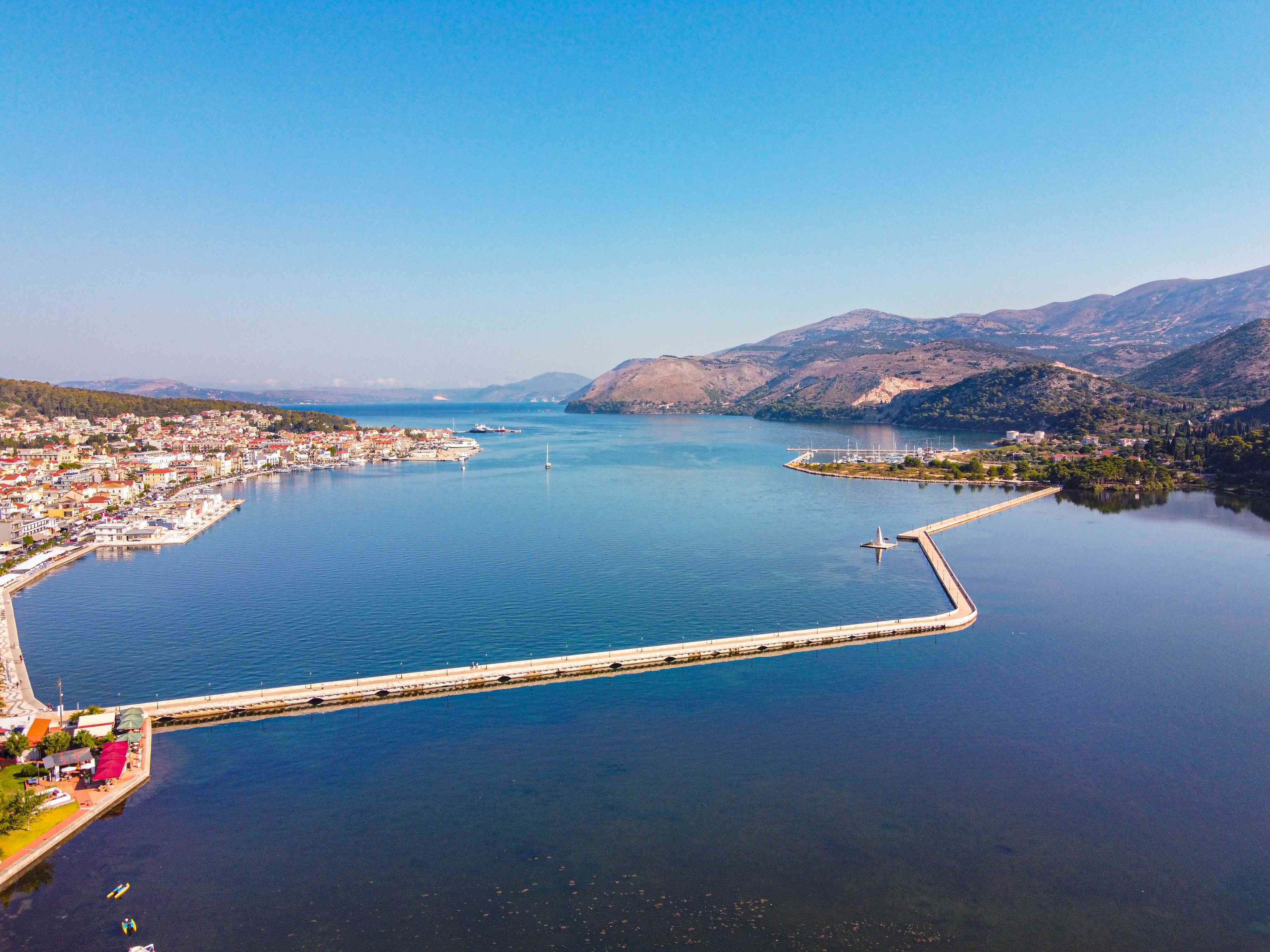
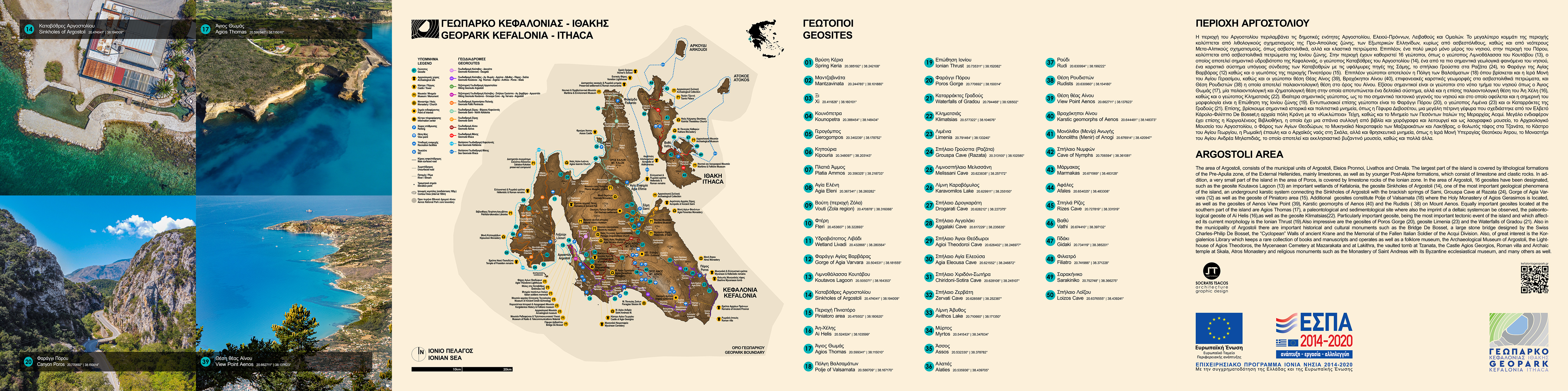
From Koutavos lagoon, we can make a small detour and visit the Museum of Radio, Wireless and Telecommunication Equipment where we can see telephone devices and call centers of old times. We continue on the georoute to the city center in order to visit the Archaeological Museum of Argostoli, where we can admire exhibits from the Paleolithic to the Late Roman Period coming from excavations that have been conducted all over the island of Kefalonia. The Korgialeneio Historical and Folklore Museum is located nearby, where we can find objects from the everyday life of the residents of Kefalonia, such as furniture, tools, appliances, works of art, etc. The ground floor of the museum also hosts Korgialeneios Library which currently includes over 62,000 book volumes, as well as the Local Historical Archive of Kefalonia. Heading to the main square of Argostoli we can take a walk in the garden of Napier. Then, we head towards the Geosite Sinkholes of Argostoli, before which we can make a short stop in between to visit Kotsanas Museum of Ancient Greek Technology. Geosite Sinkholes of Argostoli is one of the most important geological phenomena of the island, in which the karst system of the Sinkholes is connected underground with the brackish springs of Sami, at Karavomilos.

The Lighthouse of Agioi Theodoroi is located a little further away; then we proceed along a coastal path that takes us to Geosite Piniatoro, alongside which we can admire residual erosion karstic forms such as rock arches. After the end of this path and taking the exit on the main road, about 100-200 m on the left, we can follow a second path that takes us through a rock garden (near the area of Agios Athanasios). The path ends just before the viewpoint, which the locals call "Telegraph", and can be reached by making a small detour. Alternatively, we can stay on our path towards the Monument of the Killed Italians and complete the georoute with our return to the city of Argostoli.

Georoute No 5: Paliki Peninsula
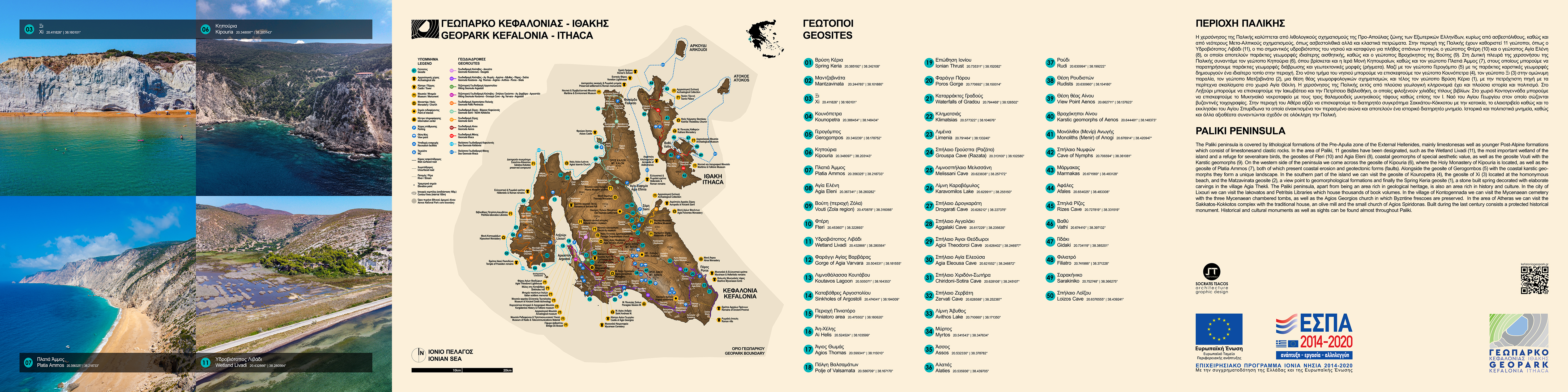
The georoute of Paliki peninsula starts from the city of Lixouri, which is the second largest city of the island. There, we can visit Iakovateios Library which includes thousands of book titles dating from the early 16th century until today, as well as a collection of objects from that period. We can also visit Petritseios Library, Lixouri public library, with more than 1400 volumes of old and rare books and a collection of old costumes. After that, we head south to Geosite Matzavinata, where from a a view point appear geomorphological formations characteristic of the whole area. We continue our georoute by making a detour to reach Geosite Xi, where it is located the homonymous beach that consists of crimson sand and unlimited raw gray clay that can be used for a natural spa. After this detour, we continue towards Geosite Kounopetra, a residual form of coastal erosion causing the constant movement of a boulder of the local coastal formation (sandstones). Then we head northwest to Chavriata and shortly after the village, we make a detour to visit Geosite Gerogompos with a picturesque lighthouse, which consists of coastal karstic geomorphs creating a unique landscape. We continue the Georoute heading towards the village of Kaminarata in order to visit Geosite Kipouria, where we can observe coastal erosion forms as well as a spectacular tectonic uplift and faults. We also have the opportunity to visit the Holy Monastery of Kipouria which is located at the same area.

Following the main road and a few meters nearby, we can make a detour to visit Geosite Platia Ammos, where we see tectonic geomorphs, some of which are traces left from the 2014 earthquake.
Then we head to Rifi village where we can make a detour towards the village of Damoulianata, so that we can visit Geosite Agia Eleni, a coastal geomorph of special beauty. Remaining on our main path, we head to the village of Agia Thekli, where –on the main road- we find the Geosite Vrysi Keria, a spring built of stone and decorated with elaborate carvings. We keep moving north and - by making a detour - we can visit the Mycenaean cemetery in the village of Kontogenada, where three-chambered tombs of the Mycenaean period have been excavated. We continue on our georoute and make a detour heading towards Atheras to visit the Sakatos-Kokotos preserved building complex which consists of a traditional house, an olive mill, and a small church of Agios Spiridon. This complex was built during the last century and has been declared a historical monument. At this point, just before we turn for Zola, we can reach Geosite Fteri through a hiking route or head towards Zola to visit Geosite Vouti, where karstic geomorphs in the limestone rocks are present and characteristic of this area. Finally, we complete our georoute heading to Geosite Wetland Livadi, which is the most important wetland of the island and home for numerous rare birds, such as herons and kingfishers, as well as many species of amphibians and fish.
Georoute No 6: Sami - Northern Kefalonia

The Sami - Northern Kefalonia georoute could also be an extension of Sami route with a starting point from the settlement of Karavomylos or the settlement of Agia Ephimia, where we can visit the mosaic floor of a Roman villa. Then, we head to the village Makriotika, where we can visit the Olive Museum of Pylaros. In the exhibition area of the Olive Museum one can see millstones and other parts of the mechanism with which the oil was extracted and stored. In the neighboring village Potamianata we can visit the stone Windmill of Sokaris of the 19th century. We continue our route going either towards Assos or towards Myrtos beach to visit Geosite Myrtos, where we can admire the beach from above the hilltop as well as observe the damaged zone of the area of Charakas, which is connected with the main road by a bridge (after the earthquake of 2014). After this short stop, we continue towards Assos Geosite, which represents the unique outcrop of the Lower Cretaceous formation of the Pre-Apulian zone on the island of Kefalonia. In the settlement of Assos we can also visit the Fortress which is a typical example of fortification of the 16th -17th century. The route continues going to the northern part of the island; by making a detour we can visit Geosite Alaties which represents a typical coastal residual erosion geomorph in limestone rocks. Lastly, the georoute of Northern Kefalonia is completed with a visit to the settlement of Fiskardo, the most picturesque destination of the island, declared as a protected settlement after the earthquake of 1953. At Fiskardo, we can visit 3 Roman monuments: a Roman Cemetery, a Roman Mausoleum and a Roman bath. It is worth a visit also to the Maritime and Environmental Museum, where there is a complete record of the natural environment and the marine fauna of Kefalonia, archeological findings, and a collection of photos with the history of the area over the centuries. Finally, we should not miss the Venetian Fiskardo Lighthouse, built by the Venetian conquerors of the area in the 16th century as well as the Early Christian Basilica church of the 6th century AD.
Georoute No 7: Sami
The Georoute in the area of Sami can be either an extension of Aenos Georoute or can stand by itself as a hiking route starting at the Watermills of Sami. This path starts just before the crossroad for the village of Chaliotata, where we take a turn towards Geosite Drogarati cave extremely rich in speleothems, which is perhaps the most important cave of the island. After that, we head to the village of Poulata where Geosite Aggalaki cave is located, an equally important and impressive cavern rich in stalactites and stalagmites. We continue our path with a visit to Geosite Agia Eleousa cave, a cavern which is also decorated with wonderful stalactites and stalagmites. At a distance of about 300m it is located Geosite Agioi Theodoroi cave, with a beautiful cavern and a blue-green lake. We continue our georoute by reaching the wider area of Poulata to visit two very interesting caves which communicate with each other through an underground siphon, the Geosite of Hiridoni - Sotiras caves. Then, we head to the area of Karavomilos, where we can initially visit Geosite Zervati Cave, a relatively small, but equally beautiful cave that contains two small lakes.
Then we continue our georoute with a visit to Geosite Karavomylos Lake with an underwater cave. We complete our route in the wider area of Karavomylos with our visit to the cenote of Melissani Geosite, which is one of the most important Geosites of the island. At this point, we could make a detour and visit the village of Old Vlachata in the area of Sami, where we find ruins of old stone houses and Venetian bridges (some of which are in fairly good condition) that were completely obliterated by the 1953 earthquakes. In this old village, a music and art festival takes place every summer. Then, we head to the settlement of Sami where we can visit the Maritime Museum as well as Sami Archaeological Collection. We complete our georoute by visiting the Ancient Acropolis of Sami with remains of a large building, possibly a temple, as well as the Roman bath and the Holy Monastery of Agioi Fanentes.
Georoute No 8: Aenos
The georoute starts from Geosite Koutavos Lagoon, which is an important wetland of the island and where it is located the Information and Training Center of the Geopark at the headquarters of N.E.C.C.A.. We head to the Castle of Agios Georgios and the church of Evaggelistria; here we can make a detour to visit the Byzantine Museum and the Holy Monastery of Agios Andreas. After that, we proceed towards the Geosite polje of Valsamata, located near the homonymus village, following the road towards the village of Troiannata. The Polje is also the location of the Holy Monastery of Agios Gerasimos, the patron Saint of Kefalonia, where his corpse and his hermitage can be visited. We continue the georoute heading towards Mount Aenos, after making a detour to Mount Roudi in order to visit Roudi Doline Geosite. On Mount Aenos, we have the opportunity to visit Geosite Rudists which is a paleontological site rich in fossils. A few meters further as we climb on the mountain, we find another Geosite with the karstic geomorphs of Aenos in limestone rocks which form the mountain itself. Lastly, we reach Geosite View point Aenos, located just before the mountain top and from where we can observe the Plio - Quaternary formations which cover the southern part of the island.
