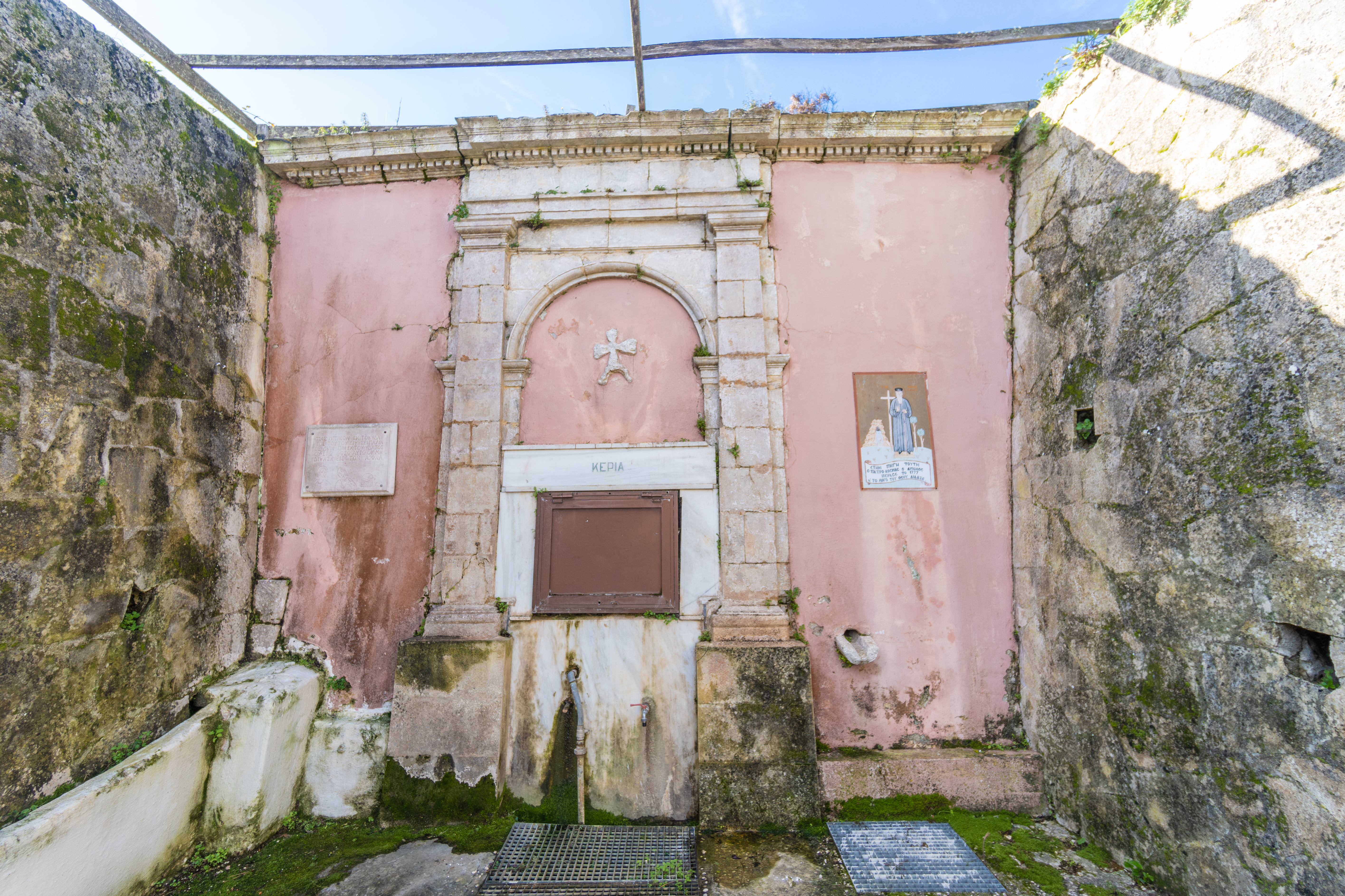
1. Spring Keria
The "Keria" spring is made of stone; it is ornamented with intensely carved decorations and is located in the village of Ag. Thekli on the Paliki peninsula. Next to the spring, there is an icon of Saint Cosmas of Aetolia, marking the passage of the monk, who is believed to have preached his teachings at that site. This part of Paliki, where the spring is situated, it is mainly covered by Neogene formations (clay sediments) that were deposited unconformably over Mesozoic limestones of the Pre-Αpoulian Zone. The Keria spring is a contact spring between Neogene and Eocene limestones, which during the past was considered as a mineral spring.
2. Matzavinata
Matzavinata village is located on the Paliki peninsula. In this village and in the surrounding villages of the area Pliocene sediments prevail, mainly blue clay sediments strongly eroded, with a characteristic appearance that differs from the rest of the island. They are geomorphological formations with main features the small ravines, erosional valleys and small streams created by mechanical and chemical weathering.
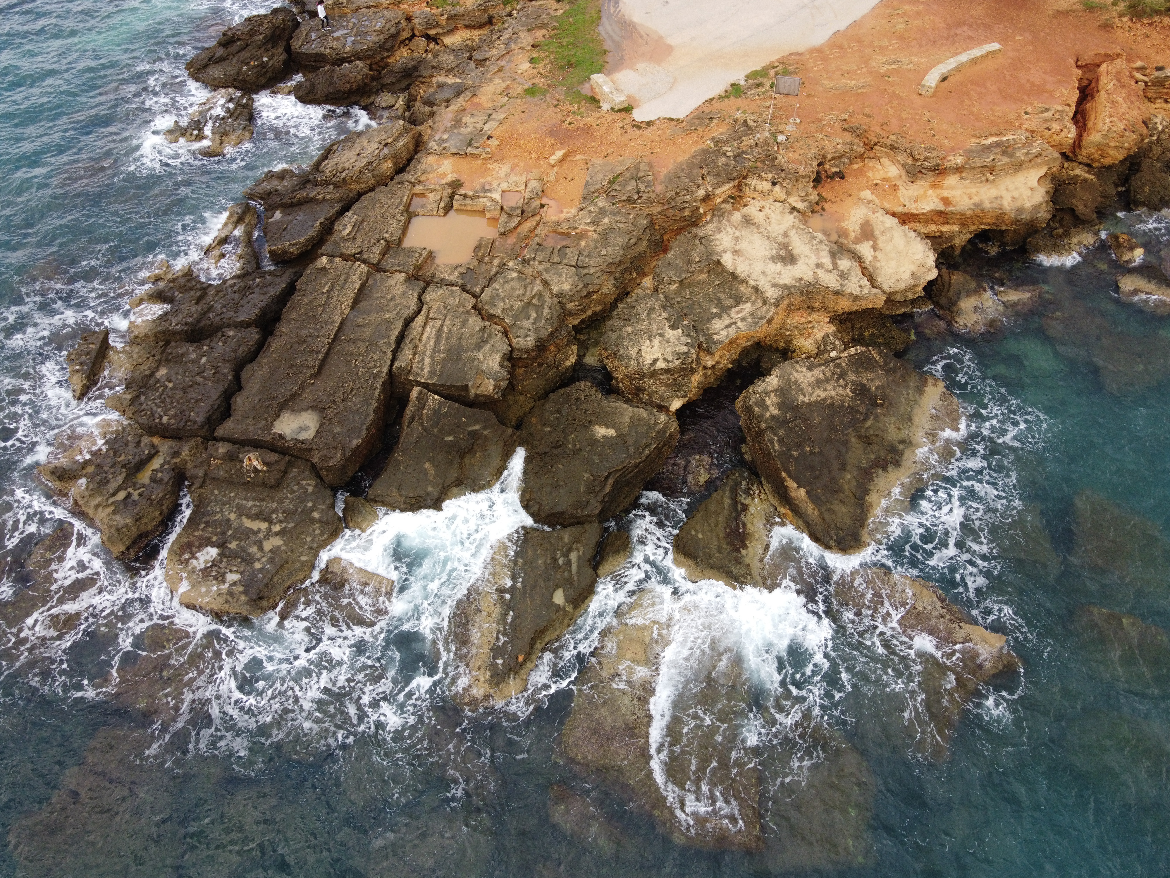
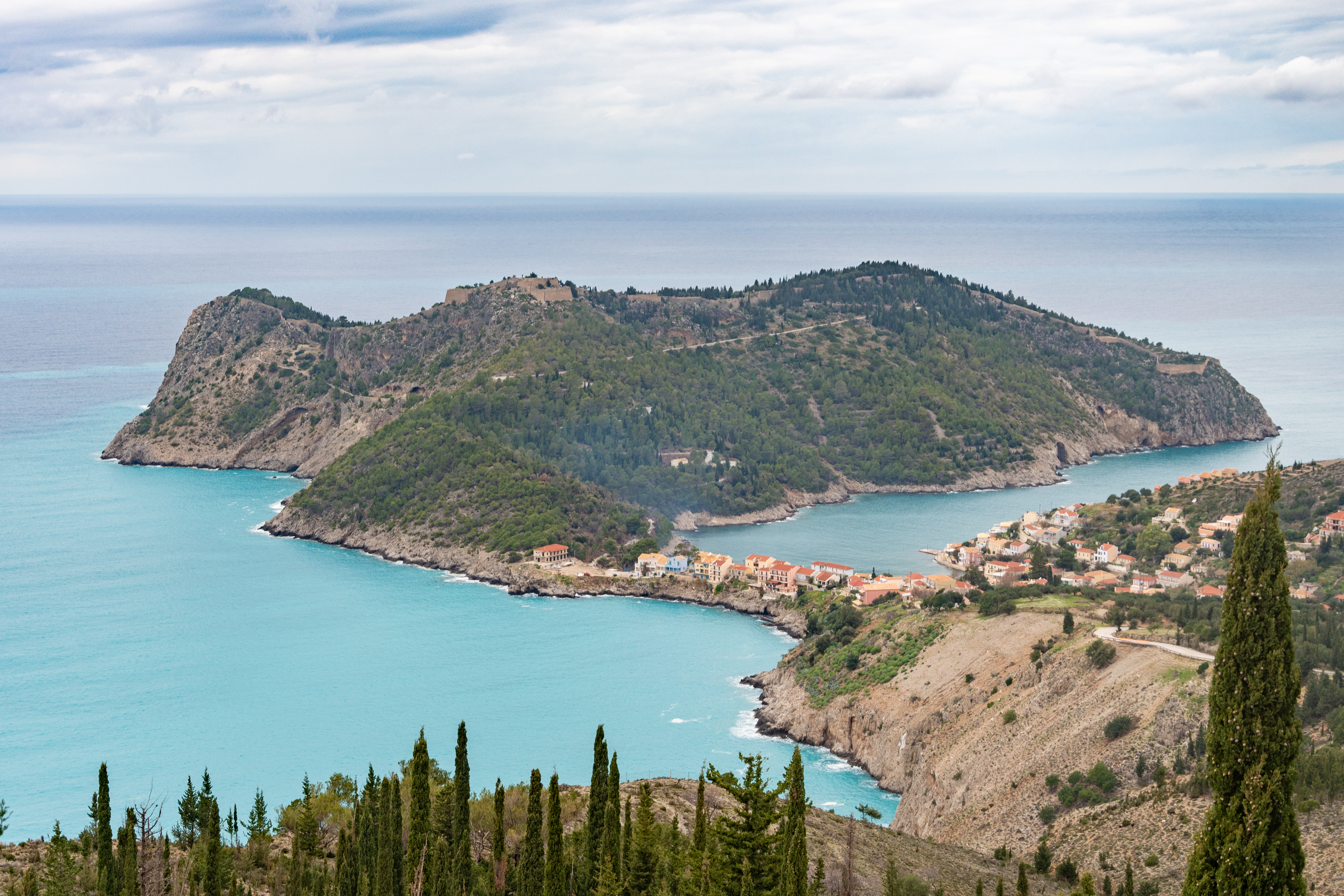
4. Kounopetra
Kounopetra is located in Paliki cape, south of the village Mantzavinata where Pleistocene sediments (mainly sandstones) prevail."Kounopetra" is one of the strange geological phenomena found in Kefalonia as a large sandstone rock seat the rocky coast "Kounopetra", was constantly moving. This perpetual motion is due to waves and the clay composition of the rocks at the bottom of the sea and the base of the rock that make it unstable.
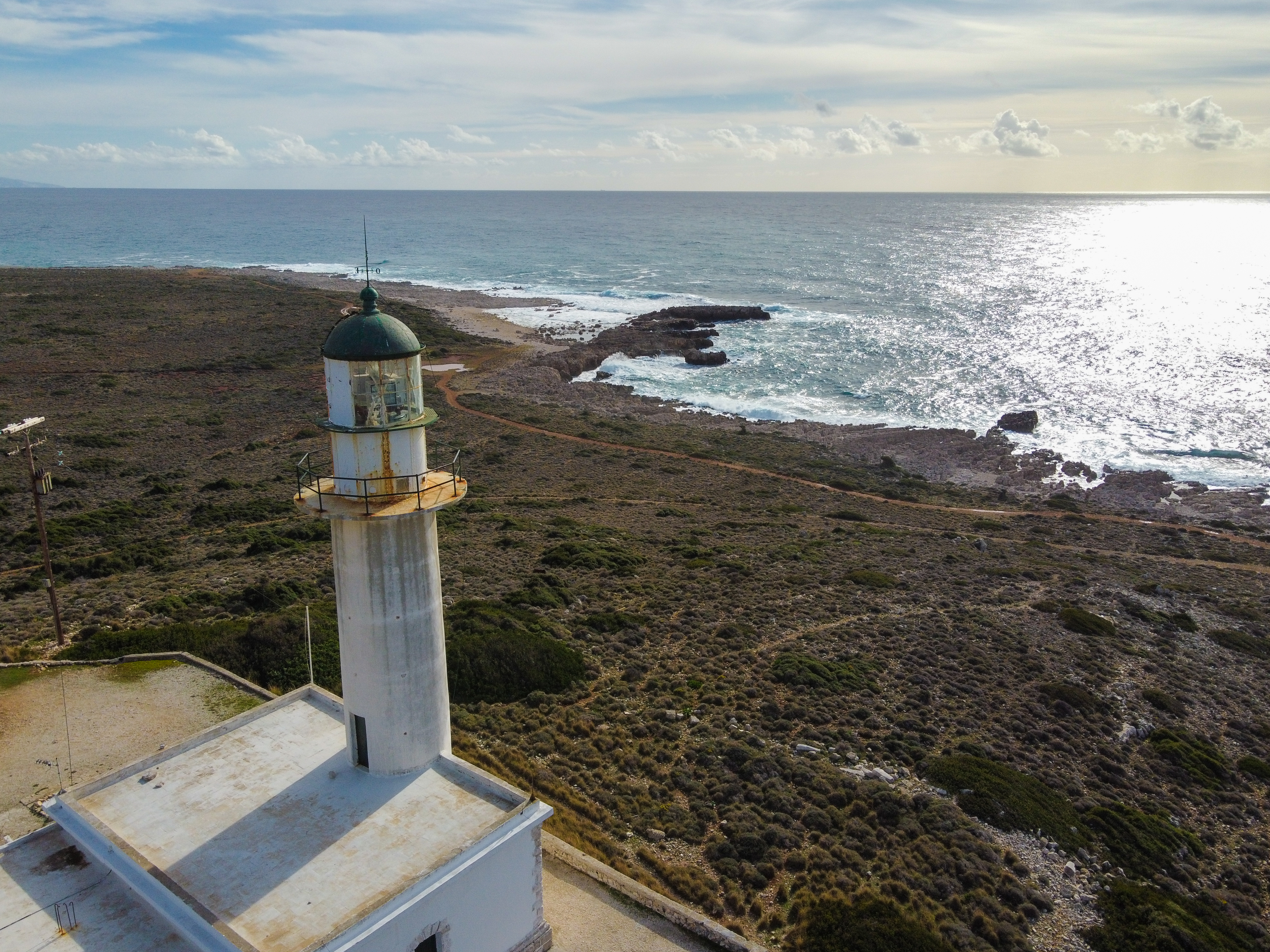
5. Gerogompos
Gerogompos cape is located in Paliki peninsula, close to the Havriata village. Because of its geotectonic location and the lithology of the area where Eocene limestones prevail, ruptures have been caused along the coastal zone as well as karstic erosion such as small coastal caves. Furthermore, near Gerogompos cape there is a historic, well-designed lighthouse of international importance. At the Cape of Gerogompos, a lighthouse of the same name was built in 1907 by the British, was destroyed by the German troops as they left the island and was rebuilt in 1947, with its light beam reaching 30 nautical miles.
8. Agia Eleni
Agia Eleni beach is a beautiful, quiet beach located at the western part of Paliki peninsula close to the village Damoulianata. Because of its geotectonic location and the lithology of the area where Eocene limestones prevail, ruptures have been caused along the coastal zone as well as remarkable geomorphs of karstic erosion.

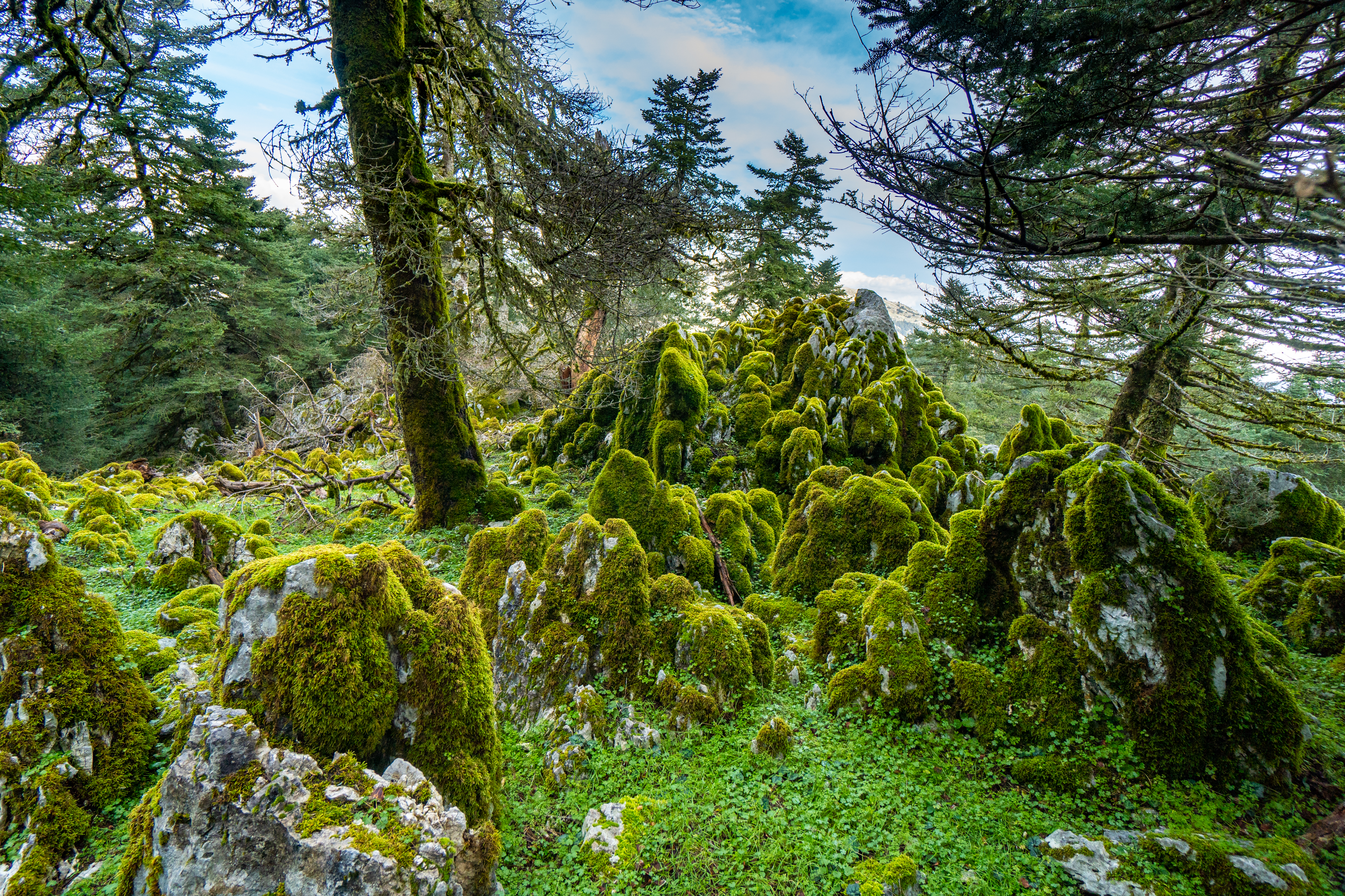
9. Vouti (Zola region)
Vouti Beach is located in the northern part of Paliki peninsula where Miocene sediments occur. In the wide area Eocene limestones prevail, as well as Upper Cretaceous limestone’s but in a lesser extent. In this area, due to the lithology as well as to the intense tectonics that prevail, there is an impressive "rock garden" (karstic geomorphs), which consists of scattered large boulders that compose an impressive stony landscape.
10. Fteri
Fteri beach is located in the northern part of the Paliki peninsula. The access to the beach is done by foot with considerable difficulty, as the road stops almost two kilometers from the beach. Alternatively, we can visit it by boat. The area is characterized by the impressive appearance of Upper Cretaceous limestones as well as of karstic geomorphs of erosion. On the beach, there was an impressive erosional rocky arch which was destroyed during the 2014 earthquake.
15. Piniatoro area
Piniatoro is located in Lassi area, close to the Lighthouse (Fanari) of Saint Theodore, where Late Cretaceous limestones prevail. Due to erosional processes, karstic geomorphs such as grooves, small pits and sea arches are formed in these limestones, creating a distinctive landscape.
16. Ai Helis
Ai Helis beach is located near the village of Svoronata in Livathos. Pliocene sediments predominate in the area, mainly blue marls which contain a rich malaco-fauna. Ai Helis is a rich fossiliferous site wherea taphocoenosis of marine bivalve molluscs (Pectinidae) can be found.
19. Ionian Thrust
The pre- Apoulian zone almost prevails on Kefalonia Island. During the Pliocene the Ionian zone thrusted over the Pre- Apoulian one. This event is the most important tectonic event of Kefalonia that forms the current geomorphology of the island. The Ionian thrust can be observed alongside the road network from Sami to Poros, where Pantokrator limestones (Ionian zone) are thrusted over the Miocene marls of pre- Apoulian zone.
21. Waterfalls of Gradou
One of the most impressive sights of the island in the area of Eleios-Pronnon is the "waterfalls" of Gradou. Waterfalls of Gradou, is a gorge that is formed in Miocene limestones of the Pre-Apoulia zone with many small waterfalls and small lakes between Skala and Poros. The largest waterfall is about 18 m high. You can reach the Waterfalls of Gradou only by foot following a very pleasant path.

22. Klimatsias
The beach of “Klimatsia” is located at the southern part of Kefalonia in the village of Spartia in the area of Livathos which is believed to have taken its name from the loud noise made by the waves when they crash onto its impressive rock formations. The beach is dominated by Pliocene sediments such as sandy limestones, which are rich in fossil Echinidae (Echinoids) and Pectinidae (bivalves), as well as thick blue clay sediments. These blue sediments are characterized by intense erosion forms which are created due to the mechanical and chemical processes of water.
23. Limenia
Residual forms of erosion are located along the road network from Skala to Poros in the area of Eliou-Pronnon. These forms are remnant erosion geomorphs of Oligocene-Miocene conglomerate limestones of the Pre-Apulian zone characterized as marine notches.These sea notches were formed due to sea-level change, being indicators of this change, either due to eustatism or due to the tectonic uplift that followed their formation.
28. Aggalaki Doline
The doline of Aggalaki is surrounded by a low stone wall with a railing. It starts as a pothole with a large opening with a diameter of about 20 m. The opening of the doline comes from the collapse of the roof creating a cone of scree. From the one side, we find a large chamber with speleothems which in its lower part ends up in a lake of about 5 m. The cave has a second chamber with speleothems as well, while at the end of the cave a second small lake is found. Unfortunately, the cave does not continue. A large colony of bats populates this cave.
30. Agia Eleousa Cave
The Agia Eleousa doline is located about 300 m from the Agioi Theodori cave. It is a vertical doline of 50 m at its lowest height and 70 m at its greatest. Scree from the collapse of the ceiling at the center goes downto the north to the edge of a first lake, which is 26 m wide and 15 m long. From this lake a siphon begins, about 300m long with beautiful decoration. On the south side of the gallery another siphon, almost 150m long, which gets to a gallery with air about 50m wide and 30m long. It is a superbly decorated cave with: stalactites, stalagmites, columns, draperies follow one another, often intact and with very beautiful colors.
31. Chiridoni-SotiraCave
Chiridoni can be reached from the road or by following the path that leads to Agia Eleousa doline. It is a vast collapsed doline in the southern part of which a siphon over 500m begins. It actually consists of two large galleries, more than 20 m. It is fairly rich in speleothems. At the end of the second room, after a narrow passage through large collapsed blocks, we come across the scree cone of the cave of Sotira, with which it is connected.
33. Avithos Lake
Lake Avithos is one of the two natural lakes of Kefalonia which is located in the southeastern part of the island, near the village of Agios Nikolaos in the province of Poros. The name Avithos (a greek word which means without a bottom) derives from the perception that this lake is so deep that no one could find its bottom. Lake Avithos is a karstic lake found in Upper Cretaceous limestones of the Pre-Apulia zone which has a depth of only 11mand which is connected underground with the wider karstic network of the area.
35. Asos
Asos is one of the most popular sites of Kefalonia and is located in the northern part of the island. Apart from its special beauty due to its picturesqueness, it is the only area where there is a significant surface outcrop of lithological formations of the Lower Cretaceous of the Pre-Apulian zone. Also in Asos we can visit the Venetian fortress (castle).
37. Rudi
Roudi is an extension of the mountain range of Aenos to the NW, and consists the second part of the National Park with a height of 1,125 m (peak Jupari). In this area, Upper Cretaceous limestones of the pre- Apulian zone prevail. On the eastern edge of Mount Roudi there is a large doline at the bottom of which the cave of Agios Nikolaos of Grouspa is found. The forest of Roudi consists of Kefalonian fir and other evergreen trees.
38. Rudists
In Aenos Mountain mainly limestones of the Upper Cretaceous predominate and in the lower parts of its southwestern slopes, dolomites of the Lower Cretaceous. These limestones were deposited at the bottom of the ocean of Tethys and contain many and various fossils of marine organisms such as Foraminifera, Rudists and Gastropods. The most characteristic fossils of Aenos are the Rudists which we find in abundance in the Geosite of Rudists.
39. Karstic geomorphs of Aenos
The mountain range of Aenos is located in the southeastern part of Kefalonia near Argostoli and Sami, and constitutes the main mountain of the island as well as the highest mountain of the Ionian Islands. Due to the lithological composition and the intense tectonics that prevail, it resulted in the formation of various "karstic" geomorphs, creating an impressive petrosphere, with cavities of karstic erosion and caves (Nifi Cave, Petasi Cave).
40. View position Aenos
The Aenos mountain range is the main mountain range of the island and the highest mountain of the Ionian Islands. Its highest peak is Megas Soros (1627 m.) and has a ridge length of 11 km. It is the result of a series of successive tectonic deformation episodes, mainly of compressive nature.From the view position we can see the intense geomorphology of the mountain as well as the view towards the Southern part of Kefalonia.